Ever wonder how GIS works!?
What is GIS?
A geographic information system (GIS) is a computer system that generates, manages, analyses, and maps various types of data. GIS connects data to a map by combining location data (where things are) with various types of descriptive data (what things are like there). This lays the groundwork for mapping and analysis, which are used in science and almost every industry. GIS assists users in comprehending patterns, relationships, and geographic context. Improved communication and efficiency, as well as better management and decision making, are among the advantages.
GIS allows you to compare and contrast many different types of information. Data about people, such as population, income, or education level, can be included in the system. It may contain information about the landscape, such as the location of streams, various types of vegetation, and various types of soil. It may include information about the locations of factories, farms, and schools, as well as storm drains, roads, and power lines.

People can use GIS technology to compare the locations of various things in order to discover how they relate to one another. For example, using GIS, a single map could include both polluting sites, such as factories, and polluting sensitive sites, such as wetlands and rivers. A map like this would assist people in determining where water supplies are most vulnerable. Map creation and geographic analysis are not new concepts, but a GIS performs these tasks better and faster than manual methods. And, prior to GIS technology, only a few people possessed the skills required to use geographic information to aid in decision making.
Components of GIS:
Hardware, software, data, people, and process are all essential components of a functioning GIS.
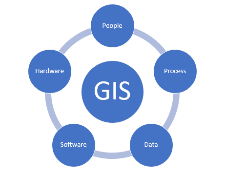
- Hardware: Hardware refers to the machine that a GIS runs on. GIS software may now be run on a variety of hardware, ranging from centralised computer servers to desktop computers in standalone or networked systems.
- Software: GIS software includes features and tools for storing, analysing, and displaying geographic data. Tools for the input and manipulation of geographic data are important software components. A database management system (DBMS), often known as a relational database management system (RDBMS), is a software Query, analysis, and visualisation tools for geographic data AND A graphical user interface (GUI) for quick tool access.
- Data: Data is maybe the most crucial component of a GIS. Geographic and tabular data might be gathered in-house or obtained from a commercial data supplier. A GIS may connect spatial data with other data sources and even manage spatial data using a database management system (DBMS), which is used by most enterprises to organise and preserve their data.
- People: Without the people who manage the system and make ideas for applying it to real-world problems, GIS technology is worthless. Users of GIS range from technical specialists who create and manage the system to those who utilise it in their daily activities.
- Process: A good GIS follows a well-designed plan as well as business rules, which are the models and operational processes that are specific to each corporation.
How does GIS work:
This process of GIS, is done in 6 stages, they are
- Input: Data must be transformed into a suitable digital format before it can be used in a GIS. Digitization is the process of transferring information from paper maps to computer files. For major projects, modern GIS technology can fully automate this procedure using scanning technology; however, smaller works may require manual digitisation (using a digitising table). Many forms of geographic data are now available in GIS-friendly formats. These data can be gathered from data providers and then imported into a GIS directly.
- Manipulation: Data types required for a specific GIS project will almost certainly need to be changed or altered in some way to make them compatible with your system. Geographic data, for example, is available at several scales. This data must first be translated to the same scale before it can be incorporated. This could be a one-time transformation for display or a long-term transformation necessary for analysis. GIS technology provides a variety of tools for modifying spatial data and removing irrelevant information.
- Management: For modest GIS projects, storing geographic data as basic files may be adequate. When data volumes grow huge and the number of data users grows beyond a handful, it’s time to turn to a database management system (DBMS) to help store, organise, and manage data. A database management system (DBMS) is computer software that manages a database, which is a collection of data that is linked together.
- Query: Once you have a working GIS with all of your geographic data, you can start asking simple questions like, who owns the property piece on the corner? What is the distance between two points? Where can I find land that is zoned for industrial use?
- Analysis: There are analytical questions like: Where are all the building sites?
What is the most common soil type in an oak forest? What will happen to traffic if a new motorway is built here?
- Visualization: A map or graph is the best way to visualise the end result of various types of geographic operations. Maps are extremely useful for storing and communicating geographic data. GIS gives new and fascinating tools to enhance the art and science of cartography, which has been done for millennia. Reports, three-dimensional views, photographic pictures, and other output, such as multimedia, can all be integrated into map presentations.
GIS APPLICATIONS:
Geographic information system (GIS) technology combines geographic science with tools for understanding and collaboration. It assists people in achieving a common goal: gaining actionable intelligence from all types of data.
- Maps: Maps are the geographic container for the data layers and analytics you want to work with. GIS maps are easily shared and embedded in apps, and they are available to almost everyone, everywhere. Maps can be used to share almost anything you do with GIS. And they can go wherever they want. GIS maps work online and on any smartphone, and they are available at any time, along with your supporting GIS work.
- Apps: apps are targeted user experiences that help you get work done and bring GIS to life for everyone. GIS apps can be used on almost any device, including mobile phones, tablets, web browsers, and desktop computers.
- Data: Using spatial location, data GIS integrates many different types of data layers. The majority of data has a geographic component. Imagery, features, and base maps are all linked to spreadsheets and tables in GIS data.
- Analysis: Spatial analysis enables you to assess suitability and capability, estimate and predict, interpret and comprehend, and much more, providing new perspectives for your insight and decision-making.
Advantages of GIS:
The following are some of the benefits of using a geographic information system:
- Improved decision-making — specific and thorough information about one or more locations is displayed, making decisions easier.
- Reduce expenses and improve efficiency, particularly in the areas of maintenance, fleet movements, and scheduling calendars.
- Because the visual format is easily understood by anyone, communication between any concerned organisations or departments improves.
- Easy recordkeeping – GIS makes it simple for people in charge of keeping track of changes to record them.
- Knowing what is and will be happening in a geographic space in order to plan a course of action is known as geographical management.
GIS TOOLS:
There are many tools in processing the GIS, some of them are
- PostGIS
- ArangoDB.
- SpatiaLite TerraLib
- OrientDB
- GeoNetwork opensource
- pycsw
- Chameleon
These tools, as well as many more related to computer equipment, can be found on the website of “X-TECH BUY,” one of Melbourne’s most popular purchasing websites. This website, https://www.xtechbuy.com/, sells a variety of software and hardware security products and many others.
if you want to know more about or stuck in between and need help using this technology this you can contact the experts “Computer Repair Onsite (CROS)” from their website here.